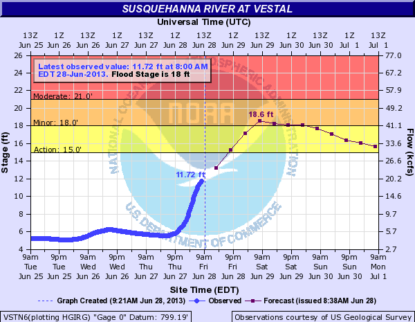
The National Weather Service in Binghamton is forecasting minor flooding for the Susquehanna River at Vestal, NY in Tioga County from late tonight to Sunday afternoon. The river is expected to rise to 18.6 feet Saturday morning. Flood Stage is 18 feet. At 18 feet, Flood stage. The river overflows banks and lowland flooding begins within the flood plain. Alert Info: http://inws.wrh.noaa.gov/weather/alertinfo/11277807 Outside are forecast area, this does in include Broome County, NY. |
Showers and thunderstorms will move over the region this afternoon and continue into Friday. These thunderstorms will be capable of producing torrential downpours. Rainfall rates in excess of one inch per hour will be common in most storms. Rapid rises in streams...creeks...poor drainage...and urban areas are likely.
Rainfall amounts will be generally around 1 to 2 inches with up to 3 inches in the heavier thunderstorms. Flash Flood Watch: https://nwschat.weather.gov/vtec/#2013-O-NEW-KBGM-FF-A-0004/DMX-N0Q-0 Areal Flood Watch: https://nwschat.weather.gov/vtec/#2013-O-NEW-KBUF-FA-A-0004/DMX-N0Q-0 The National Weather Service’s NCEP Weather Prediction Center (WPC) is forecasting in there Quantitative Precipitation Forecast (QPF) that rainfall on Thursday and Friday could total 1 to 3 inches. They are also indicating that in the Southern Tier that a significant river flood during the period of June 11–16, 2013 is POSSIBLE, this is the lowest category in their outlook and should not indicate that a river flooding threat is imminent.
You can monitor later forecast from the Weather Prediction Center (WPC), the NWS Middle Atlantic River Forecast Center, or follow us here and on twitter. Comment below and I will try and answer any questions or give additional information. |
|